Special offer Lenin Peak 2024

Special offer Lenin Peak 2024

Climb Lenin Peak with Maximum comfortable packs, ideal for entry-level climbers.

More info in Russian

Key information:

Duration of the tour: 22 days
Elevation: 7134 m
Location: Kyrgyzstan
Lat/Lon: 39.34690°N/72.86920°E
Peculiarity: High altitude climbing, mountaineering & Maximum comfortable packs, ideal for entry-level climbers.
Season: July – August; Base Camp in 2024, will operate between 1st of July and 1st September 2024.
All inclusive GUIDED tours with guaranteed departure dates: Available
The cost of international flights:
 Not included
The cost of local flight: Included (In Bishkek – Bishkek packages only)
The cost of personal insurance: Not included
Personal equipment: Available at extra cost.

Supplier of services: ClimberCA International ConsortiumAbout Us.
https://t.me/ClimberCA – telegram; +7966 065-53-44 – whatsapp/viber
e-mail – your.climberca@ya.ru
Note: ClimberCA offers to you the best service & the firm prices of all kind of services we offer on our web-pages. Some services, which we offer to you, are truly unexampled.

Basic program: 22 days

Lenin Peak from the Garlic Field  Lenin Peak. Hike to camp 1 (4200 m) Lenin Peak. Lenin glacier

International Mountaineering Camp (IMC) “Pamir” will be active between 1st of July and 1st September 2024.
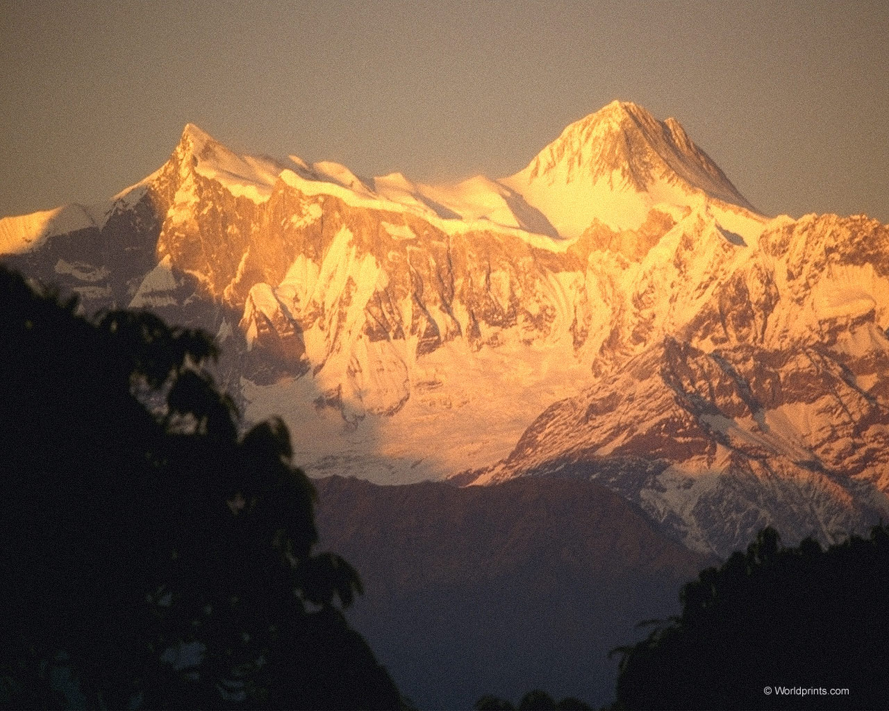
Situated in the Pamirs on the border between Kyrgyzstan and Tajikistan, close to the borders with China and Afghanistan, Lenin Peak is one of only five 7000 meter peaks in the former USSR. At 7134 meters it is the third highest, the others being Peak Communism (7495m) and Korzhenevskoy (7105m), both in the Pamirs, and Pobeda Peak (7,439m) and Khan Tengri (7010m) in the Tien Shan. To climb all five admits you to the elite group of Russian climbers known as Snow Leopards. Lenin Peak is considered the most accessible 7000-meter mountain. There is a high way going almost to the foot of the peak. Also Lenin Peak by the normal Razdelnaya route is practically no technical climbing involved.

Route Description

IMC “Pamir” is located in the foot of Petrovskiy Peak in Achik-Tash valley near the big river. The ground is a carpet of wild garlic and alpine flowers. From IMC “Pamir” we head over the Puteshestvinnikov Pass (4200m). The ascent usually takes 1-1.5 hours by a good path. Sometimes there is snow on the pass. Then we descend to the left moraine of the Lenin glacier. Further we should cross the river carefully. The best time for crossing is early morning, as the river rises rapidly throughout at this time. Across the left moraine of glacier to the Lenin glacier (4100m) and hike to camp 1 (4400 m).
From camp 1 at 4400 meters, we cross the dry Lenin Glacier and ascend the long snow slopes which run directly to the summit (north face). At 5000 meters we traverse to the west and, ascending gently, we arrive at the rim of a large snow basin. We cross this, traversing beneath Razdelnaya Peak. A short climb up a scree/snow slope leads to camp 2. There are a few crevasses on this section of the route but it is straightforward snow plodding. It is, however, a long and tiring day, and an early start is needed to avoid the worst effects of the sun. Directly above camp 2 is an easy-angled couloir which leads to the north ridge of Razdelnaya Peak (6148 meters). Initially the ridge is almost level, but as we approach Razdelnaya Peak the angle steeples.

The final 400 meter climb to the summit of Razdelnaya Peak is straight-forward but the effects of altitude make it hard work. The views from the summit are superb. To the north we can finally get the true perspective of the Alai Plain while to the south there are a multitude of snowy peaks. Peak Communism and Korzhenevsky dominate our view of the south Pamirs. Further east the Wakhan and Hindu Kush are clearly visible, and on a good day it is possible to make out Tirich Mir. From Razdelnaya Peak the ridge dog-legs to the west and drops down 100 meters to Razdelnaya Pass at 6000 meters. It is here that we will make camp 3.

From camp 3 the whole of the summit ridge is visible. From here we will have two options. Either we climb directly to the summit and back to camp 3 in one long day, or we place a fourth camp at about 6400 meters. From camp 3 we follow the broad ridge to a plateau (the site of camp 4) at 6400 meters. We traverse this back to the ridge proper where it steepens to form a short step which is turned on the north side. Above this the ridge is broken and rocky until we reach a large snow plateau. We traverse this and rejoin the ridge just below the summit.

The summit at 7134 meters is crowned by a number of plaques, including one of Lenin himself. The views, as you would expect, are outstanding and stretch right across the Pamirs to Mustagh Ata and Kongur in China. Further in the distance is the Hindu Kush and further west still the Karakoram.

Continue reading

Trekking in Himalayas. Annapurna Base Camp trek

Anapurna Base Camp Trek

Russian >>>

Annapurna Base Camp Trek is the most popular trek in the Annapurna Region Trekking Package. It provides views of both cultural and natural beauties. Trekkers have always demanded and admired this route for trekking. At the end of the trek, the beautiful views around just turn to beautiful memories. This is the reason why explorers find it fascinating to get into this area.

Supplier of services: ClimberCA International ConsortiumAbout Us
https://t.me/ClimberCA – telegram
WhatsApp / Viber +7966 065-53-44
e-mail – your@climberca.com
Note: ClimberCA offers to you the best service & the firm prices of all kind of services we offer on our web-pages. Some services, which we offer to you, are truly unexampled.

Trekking in Annapurna Base Camp Area takes you to the centre of the entire Annapurna Range. This place is perfect with magnificent design of the formation of mountains. The glaciers and snow-capped peaks around the area add a different flavour to the trek. Also, there is Annapurna Sanctuary surrounded by the high Himalayas of the Annapurna Range named Mt. Machapuchchre[6991m/22,936ft], Mt. Gangapurna[7454m/24,455ft], Mt. Annapurna 1[8091m/26,545ft], Unclimbed fang[7647m/25,088ft] and Annapurna south[7273m/23,861ft].

Continue reading

Mt. Gyajikang 7,038m. / 23,090 ft. Expedition

Mt. Gyajikang 7,038m. / 23,090 ft. Expedition

Gyajikang

Пик Гьяджикэнг 7038 м

Gyajikeng Peak is located in the Peri Himal mountain system northeast of Manang and is open for climbing only after 2002. It is interesting for its height and the availability of routes from relatively simple to technically complex.

Восхождение на пик Гьяджикэнг 7038 м. >>>

Expedition Itinerary: A

Day 01: Arrival in Kathmandu airport, meet our staff then transfers to Hotel.
Day 02: Kathmandu free.
Day 03: Official works for expedition and briefing by officer of Ministry of Tourism.
Day 04: Kathmandu – Khuldi then transfer to Teahouse/Tented Camp.
Day 05: After Porter arrangement start to walk – Ngadi overnight.
Day 06: Ngadi – Jagat 1314m.
Day 07: Jagat – Dharapani 1943m.
Day 08: Dharapani – Koto 2713m.
Day 09: Koto – Daramsala.
Day 10: Daramsala – Phugaon.
Day 11: Phugaon – Gyajinkhan Base camp.
Day 12-22: Climbing Period of Gyajikang 7038m.
Day 23: Base Camp Clean up and preparation.
Day 24: Base Camp – Daramsala. Tented Camp
Day 25: Daramsala – Dharapani.
Day 26: Dharapani – Jagat.
Day 27: Jagat – Ngadi.
Day 28: Ngadi – Bhulbhule & drive back to Kathmandu then transfer to Hotel.
Day 29: Kathmandu free.
Day 30: Last minute, transfer to airport for onward journey.

Expedition Itinerary: B
(Entry: Pokhara, Exit: Besi Shahar)

Day 01: Arrival in Kathmandu airport, meet our staff then transfers to Hotel.
Day 02: Kathmandu free.
Day 03: Official works for expedition and briefing by officer of Ministry of Tourism.
Day 04: Kathmandu – Pokhara by tourist Bus then transfer to Hotel.
Day 05: Pokhara – Manang (Humde) 3195m. flight and overnight.
Day 06: Humde rest for acclimatization.
Day 07: Humday – Ngawal village.
Day 08: Ngawal – Camp under Kang La pass.
Day 09: Kang La Pass BC – Nar village.
Day 10: Nar Village– Gyaji Kang Base Camp.
Day 11-21: Climbing periods for Gyajikang 7038m.
Day 22: Base Camp Clean up and preparation.
Day 23: Base Camp – Daramsala.
Day 24: Daramsala – Dharapani.
Day 25: Dharapani – Jagat.
Day 26: Jagat – Ngadi.
Day 27: Ngadi – Bhulbhule and drive back to Kathmandu then transfers to Hotel.
Day 28: Kathmandu free.
Day 29: Kathmandu free.
Day 30: Last minute, transfer to airport for onward journey.

ClimberCA International Consortium
https://facebook.com/enclimberca
https://facebook.com/climberca
www.ClimberCA.com
www.ClimberCA.ru
www.PageTour.org
https://t.me/ClimberCA – telegram
WhatsApp / Viber +7966 065-53-44
e-mail – your@climberca.com


Langtang Valley Trek

Langtang Valley Trek

Russian >>>

11 Days Trekking in Langtang region. Langtang valley trek is typical Tamang and Sherpa village tours Langtang Valley, Beautiful Langtang Lirung, Yala Peak, Tamang culture, wilderness route, typical buddhist culture

Supplier of services: ClimberCA International ConsortiumAbout Us
https://t.me/ClimberCA – telegram
WhatsApp / Viber +7966 065-53-44
e-mail – your@climberca.com
Note: ClimberCA offers to you the best service & the firm prices of all kind of services we offer on our web-pages. Some services, which we offer to you, are truly unexampled.

The Langtang Valley Trek is the most famous trekking route in the Langtang Region. This trek provides you the beautiful views of the Langtang Valley, Langtang Lirung, The Yala peak and the rich wilderness route of the Langtang Region. Interacting with people of Tamang ethnicity here is like sharing the best Buddhist culture anywhere in the world. All these prime factors together form up a trekking package known as Langtang Valley Trek.

Continue reading